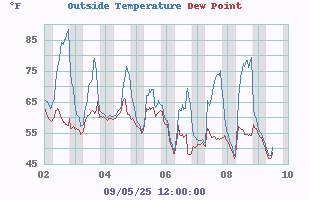
Outside Temperature
Temp: 79.5°F Colder 1.1°F than last hour.
Humidity: 72%
High: 84.3°F @ 1:22pm
Low: 64.4°F @ 5:13am
Warm
Feels like: 79.5°F
24-hr difference -- -4.5°FColder 4.5°F than yesterday at this time.
wind graph
Records Highs: Lows:
Yesterday: 86.0°F 54.1°F
7:03pm 6:18am
Record: 105.6°F -2.4°F
07/16/2024 01/22/2025
Daytime
Records:
°F
7/16/2024
°F
1/25/2026
Nitetime
Records:
°F
7/06/2024
°F
1/22/2025
Barometer

wind graph
Current: 30.059 inHg Rising 0.002 °F/hr
1-Hr Trend: Steady
3-Hr Trend: Steady
Today: Todays High 30.101
Todays Low 30.006
Record High: 31.100 inHg
02/18/2024
Record Low: 29.146 inHg
02/16/2025
Heat Index
Current: 81.7°F
Today: 88.9°F  13:22
Yesterday: 87.6°F
Last Week: 91.4°F
Record: 127.7°F   06/24/2025
Air
Quality Index: 41
Good
Density: 1.142 kg/m
Fire Risk
Chandler Burning Index
Chandler Burning Index: LOW
Currently: 3.8 at 18:45
Storm Prediction
Tonight

Tonight: Scattered showers and thunderstorms before midnight, then showers likely between midnight and 2am, then showers likely and possibly a thunderstorm after 2am.  Patchy fog after 3am.  Otherwise, cloudy, with a low around 63. Calm wind.  Chance of precipitation is 70%. New rainfall amounts of less than a tenth of an inch, except higher amounts possible in thunderstorms.
Low: 63 °F Scattered
T-storms then
Showers
Likely and
Patchy Fog
Saturday

Saturday: Showers and possibly a thunderstorm.  Patchy fog before 1pm. High near 76. Calm wind.  Chance of precipitation is 80%. New rainfall amounts between a tenth and quarter of an inch, except higher amounts possible in thunderstorms.
High: 76 °F Showers and
Patchy Fog


Saturday
Night
Saturday Night: Showers and possibly a thunderstorm before midnight, then showers likely.  Patchy fog after 11pm. Low around 64. Calm wind.  Chance of precipitation is 80%. New precipitation amounts between a tenth and quarter of an inch, except higher amounts possible in thunderstorms.
Low: 64 °F Showers and
Patchy Fog


SPC Activity Map
Rain

rain graph

Today 0.32 in
Yesterday: 0.59 in
Last 7 Days: 0.91 in
Jun Rain: 0.91 in
Jun Avg: 0.00 in
YTD: 13.73 in
54 rain days in 2026
2 days in June
UV Summary/Forecast
Fri 26

  9.1
Burn Time:
15 min
Sat 27

10.0
Burn Time:
10 min
Sun 28

10.4
Burn Time:
10 min
Cloud Height
Wind
 Calm Calm
Average: 0
Gust: 0
1Hr Average: Calm
Wind Run: 23.4 miles
Wind Gust
Today: 9 mph 12:41pm
Month: 24 mph 06/11/2026
Year: 31 mph 03/16/2026
Record Gust: 37 mph 12/29/2025
wind graph
wind graph
Humidity/Dew Point
Humidity: 72%Increased 4% since last hour.
Humidex: 94.6°F
Today: Todays High 99.9
Todays Low 74.3
Dew Point: 69.7°FIncreased 0.7°F since last hour.
Wetbulb: 72.8°F
Record High: 99% 02/22/2024
Record Low: 18% 03/14/2026
Sun/Moon
14 hrs 58 min of Daylight Today
Light = 62.4%
Dark = 37.6%
Sun rise: 5:46am
Sun set: 8:44pm
 NWS Weather Forecast  -   Outlook Tonight & Saturday
Tonight

Tonight: Scattered showers and thunderstorms before midnight, then showers likely between midnight and 2am, then showers likely and possibly a thunderstorm after 2am.  Patchy fog after 3am.  Otherwise, cloudy, with a low around 63. Calm wind.  Chance of precipitation is 70%. New rainfall amounts of less than a tenth of an inch, except higher amounts possible in thunderstorms.
Low: 63 °F
Scattered
T-storms then
Showers
Likely and
Patchy Fog
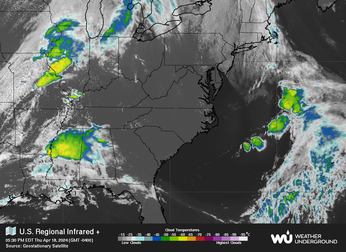
NWS forecast: Scattered showers and thunderstorms before midnight, then showers likely between midnight and 2am, then showers likely and possibly a thunderstorm after 2am. Patchy fog after 3am. Otherwise, cloudy, with a low around 63. Calm wind. Chance of precipitation is 70%. New rainfall amounts of less than a tenth of an inch, except higher amounts possible in thunderstorms.
Saturday

Saturday: Showers and possibly a thunderstorm.  Patchy fog before 1pm. High near 76. Calm wind.  Chance of precipitation is 80%. New rainfall amounts between a tenth and quarter of an inch, except higher amounts possible in thunderstorms.
High: 76 °F
Showers and
Patchy Fog


NWS forecast: Showers and possibly a thunderstorm. Patchy fog before 1pm. High near 76. Calm wind. Chance of precipitation is 80%. New rainfall amounts between a tenth and quarter of an inch, except higher amounts possible in thunderstorms.
 NWS Short Term Weather Forecast
Saturday

Saturday: Showers and possibly a thunderstorm.  Patchy fog before 1pm. High near 76. Calm wind.  Chance of precipitation is 80%. New rainfall amounts between a tenth and quarter of an inch, except higher amounts possible in thunderstorms.
High: 76 °F
Showers and
Patchy Fog


Saturday
Night
Saturday Night: Showers and possibly a thunderstorm before midnight, then showers likely.  Patchy fog after 11pm. Low around 64. Calm wind.  Chance of precipitation is 80%. New precipitation amounts between a tenth and quarter of an inch, except higher amounts possible in thunderstorms.
Low: 64 °F
Showers and
Patchy Fog


Sunday

Sunday: Scattered showers, with thunderstorms also possible after 11am.  Patchy fog before 11am.  Otherwise, partly sunny, with a high near 81. Calm wind.  Chance of precipitation is 50%.
High: 81 °F
Scattered
Showers and
Patchy Fog
then
Scattered
T-storms
Sunday
Night
Sunday Night: Scattered thunderstorms before 8pm.  Patchy fog after 2am.  Otherwise, partly cloudy, with a low around 64. Calm wind.  Chance of precipitation is 30%.
Low: 64 °F
Scattered
T-storms then
Patchy Fog

Monday

Monday: Patchy fog before 8am.  Otherwise, mostly sunny, with a high near 85.
High: 85 °F
Patchy Fog
then Mostly
Sunny

Monday
Night
Monday Night: Mostly clear, with a low around 66.
Low: 66 °F
Mostly Clear


Tuesday

Tuesday: Sunny, with a high near 92.
High: 92 °F
Sunny


Tuesday
Night
Tuesday Night: Mostly clear, with a low around 70.
Low: 70 °F
Mostly Clear


Regional Radar Regional Infrared Satellite
Radar/Satellite images courtesy of Weather Underground.

www.watsonsupply.com